Our wives and children stayed at home, and we are grateful for their support, encouragement, and strength to do it alone for almost a month. Thank you Beth and Jennifer!
It has a length overall of 43' 8", a waterline length of 36' 8", a beam of 14' 3", a draft of 4' 3", a height to clear of 23' 6", and a displacement of 33,470 pounds. It has very ample accommodations for a cruising couple with a forward master stateroom, head & shower, a galley with an electric refrigerator, a propane stove/oven, a settee and dinette, a pilothouse, a flying bridge, an aft deck with dingy, and lots of storage space. A bonus is an engine room with over 6' of headroom!
| Date | Destination at the end of the Day | Depart EDT/EST | Arrive EDT/EST | Time Underway | Log Distance | Average Speed | Latitude North | Longitude West | GC Dist | Log/GC Factor | Latitude Traveled | ICW Statute Mile # |
|---|---|---|---|---|---|---|---|---|---|---|---|---|
| 22-Oct | Harrington Harbour, Rose Haven, MD | 12:00 PM | 38.72618° | 76.54150° | ||||||||
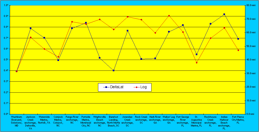
| 24-Oct | Washburn Boatyard, Solomons, MD | 9:20 AM | 1:35 PM | 4:15 | 31.5 nmi | 7.4 knots | 38.33267° | 76.45878° | 23.9 nmi | 1.316 | 0.39352° | |
| 25-Oct | Jackson Creek anchorage, Deltaville, VA | 7:20 AM | 3:15 PM | 7:55 | 56.6 nmi | 7.1 knots | 37.54483° | 76.33415° | 47.6 nmi | 1.188 | 0.78783° | |
| 26-Oct | Waterside Marina, Norfolk, VA | 7:05 AM | 2:42 PM | 7:37 | 48.0 nmi | 6.3 knots | 36.84375° | 76.29182° | 42.1 nmi | 1.140 | 0.70108° | 0 |
| 28-Oct | Coinjock Marina, Coinjock, NC | 8:34 AM | 4:00 PM | 7:26 | 42.1 nmi | 5.7 knots | 36.34858° | 75.94893° | 34.0 nmi | 1.239 | 0.49517° | 50 |
| 29-Oct | Pungo River anchorage, NC | 8:05 AM | 5:34 PM | 9:29 | 68.0 nmi | 7.2 knots | 35.55885° | 76.47138° | 53.8 nmi | 1.265 | 0.78973° | 127 |
| 30-Oct | Portside Marina, Morehead City, NC | 6:04 AM | 3:15 PM | 9:11 | 66.3 nmi | 7.2 knots | 34.71860° | 76.70510° | 51.7 nmi | 1.282 | 0.84025° | 205 |
| 31-Oct | Wrightsville Beach anchorage, NC | 6:14 AM | 5:20 PM | 11:06 | 69.8 nmi | 6.3 knots | 34.20107° | 77.80455° | 62.6 nmi | 1.114 | 0.51753° | 283 |
| 1-Nov | Barefoot Landing, North Myrtle Beach, SC | 6:52 AM | 3:52 PM | 9:00 | 62.3 nmi | 6.9 knots | 33.80110° | 78.74617° | 52.6 nmi | 1.184 | 0.39997° | 354 |
| 2-Nov | Awendaw Creek anchorage, SC | 7:06 AM | 5:26 PM | 10:20 | 71.6 nmi | 6.9 knots | 33.03432° | 79.53850° | 60.8 nmi | 1.179 | 0.76678° | 436 |
| 3-Nov | Rock Creek anchorage, SC | 6:49 AM | 4:26 PM | 9:37 | 69.5 nmi | 7.2 knots | 32.52718° | 80.48248° | 56.5 nmi | 1.230 | 0.50713° | 516 |
| 4-Nov | Herb River anchorage, GA | 6:53 AM | 4:10 PM | 9:17 | 59.8 nmi | 6.4 knots | 32.01488° | 81.03233° | 41.5 nmi | 1.441 | 0.51230° | 585 |
| 5-Nov | Wallys' Leg anchorage, GA | 6:49 AM | 4:12 PM | 9:23 | 72.4 nmi | 7.7 knots | 31.25813° | 81.39785° | 49.1 nmi | 1.475 | 0.75675° | 666 |
| 6-Nov | Fort George River anchorage, FL | 6:50 AM | 3:38 PM | 8:48 | 60.3 nmi | 6.9 knots | 30.44045° | 81.43595° | 49.1 nmi | 1.228 | 0.81768° | 735 |
| 7-Nov | St. Augustine Municipal Marina, FL | 7:57 AM | 1:03 PM | 5:06 | 37.8 nmi | 7.4 knots | 29.89213° | 81.30938° | 33.5 nmi | 1.127 | 0.54832° | 778 |
| 8-Nov | Rockhouse Creek anchorage, FL | 9:31 AM | 4:46 PM | 7:15 | 55.9 nmi | 7.7 knots | 29.06120° | 80.93117° | 53.6 nmi | 1.042 | 0.83093° | 842 |
| 9-Nov | Indian Harbour Beach anchorage, FL | 6:47 AM | 3:15 PM | 8:28 | 63.5 nmi | 7.5 knots | 28.14267° | 80.60230° | 57.8 nmi | 1.099 | 0.91853° | 914 |
| 10-Nov | Fort Pierce City Marina, FL | 6:50 AM | 1:43 PM | 6:53 | 47.0 nmi | 6.8 knots | 27.45055° | 80.32028° | 44.1 nmi | 1.065 | 0.69212° | 965 |
| Averages: | 7:21 AM | 3:46 PM | 8:18 | 57.8 nmi | 7.0 knots | 48.1 nmi | 1.222 | 0.66147° | ||||
| Totals: | 141:06 | 982.4 nmi | 11.27563° | 3.77878° | 814.4 nmi | 11.27563° |
Our daily mileage ("Log") and southing ("DeltaLat") can be seen in this graph:
2003.10.21
Lv 4:00pm	North Bend, WA
Ar 4:45pm	Seatac Airport, WA
Lv 6:54pm	Seatac Airport, WA  (on Alaska Airlines)
Ar 8:54pm	Oakland, CA  (meeting Erich)
Lv 11:18pm	Oakland, CA  (together on JetBlue)

2003.10.22
Ar 7:18am	Dulles Airport, Washington DC
Lv 8:30am	Dulles Airport, Washington DC  (in Ford Escape rental car)
Ar 12:00pm	Rose Haven, MD
N38°43.571' W076°32.490'  Harrington Harbour, Rose Haven, MD

2003.10.23
Groceries at Food Lion, supplies from Wal-Mart
Got "Skipper Bob" guides at Fawcett Boat Supplies, Annapolis, MD
N38°33.182' W076°35.808'  Food Lion, Prince Frederick, MD

2003.10.24
Lv 9:20am	Rose Haven, MD
Ar 1:35pm	Solomons, MD
31.5 nmi
N38°19.960' W076°27.527'  Washburn Boatyard, Solomons, MD

2003.10.25
Lv 7:20am	Solomons, MD
Ar 3:15pm	Deltaville, VA
56.6 nmi
N37°32.690' W076°20.049'  Jackson Creek, Deltaville, VA

2003.10.26
Lv 7:05am	Deltaville, VA
Ar 2:42pm	Norfolk, VA
48.0 nmi
N36°50.625' W076°17.509'  Waterside Marina, Norfolk, VA

2003.10.27
Explored Norfolk, VA while waiting out storm

2003.10.28
Lv 8:34am	Norfolk, VA  (ICW 0)
Ar 4:00pm	Coinjock, NC  (ICW 50)
42.1 nmi
N36°20.915' W075°56.936'  Coinjock Marina, Coinjock, NC

2003.10.29
Lv 8:05am	Coinjock, NC  (ICW 50)
Ar 5:34pm	Pungo River, NC  (ICW 127)
68.0 nmi
N35°33.531' W076°28.283'  Pungo River, NC (anchorage at end of long canals)

2003.10.30
Lv 6:04am	Pungo River, NC  (ICW 127)
Ar 3:15pm	Morehead City, NC  (ICW 205)
66.3 nmi
N34°50.870' W076°41.384'  Canal north of Core Creek bridge, NC
N34°43.116' W076°42.306'  Portside Marina, Morehead City, NC

2003.10.31
Lv 6:14am	Morehead City, NC  (ICW 205)
Ar 5:20pm	Wrightsville Beach, NC  (ICW 283)
69.8 nmi
N34°12.064' W077°48.273'  Wrightsville Beach, NC (anchorage)

2003.11.01
Lv 6:52am	Wrightsville Beach, NC  (ICW 283)
Ar 3:52pm	North Myrtle Beach, SC  (ICW 354)
62.3 nmi
N33°48.066' W078°44.770'  Barefoot Landing, North Myrtle Beach, SC

2003.11.02
Lv 7:06am	North Myrtle Beach, SC  (ICW 354)
Ar 5:26pm	Awendaw Creek, SC (ICW 436)
71.6 nmi
N33°02.059' W079°32.310'  Awendaw Creek, SC (anchorage 6 mi N of McClellanville, SC)

2003.11.03
Lv 6:49am	Awendaw Creek, SC  (ICW 436)
Ar 4:26pm	Rock Creek, SC  (ICW 516)
69.5 nmi
N32°31.631' W080°28.949'  Rock Creek, SC (anchorage 11 nmi N of Beaufort, SC)

2003.11.04
Lv 6:53am	Rock Creek, SC  (ICW 516)
Ar 9:45am	Beaufort, SC  (ICW 536)
Lv 10:35am	Beaufort, SC  (ICW 536)
Ar 4:10pm	Herb River, GA  (ICW 585)
59.8 nmi
N32°25.193' W080°39.519'  Lady Island Marina, Beaufort, SC (walked to Winn Dixie)
N32°00.893' W081°01.940'  Herb River, GA (anchorage just south of Palmer-Johnson)

2003.11.05
Lv 6:49am	Herb River, GA  (ICW 585)
Ar 4:12pm	Wallys' Leg, GA  (ICW 666)
72.4 nmi
N31°59.473' W081°01.441'  University of Georgia Marine Extension Aquarium
N31°48.600' W081°00.900'  9:12am, east at ICW 605 in Ogeechee River for Atlantic Ocean
N31°38.971' W081°02.020'  Offshore 5 nmi in the Atlantic Ocean
N31°32.448' W081°12.532'  12:12pm back in at ICW 635 Blackbeard Island, GA
N31°15.488' W081°23.871'  Wallys' Leg, GA (anchorage 6 nmi N of Brunswick, GA)

2003.11.06
Lv 6:50am	Wallys' Leg, GA  (ICW 666)
Ar 3:38pm	Fort George River, FL  (ICW 735)
60.3 nmi
N30°53.231' W081°30.872'  Westernmost point of trip (ICW 700)
N30°42.500' W081°27.800'  Entered Florida
N30°26.427' W081°26.157'  Fort George River, FL (anchorage 5 mi N of Mayport, FL)

2003.11.07
Lv 7:57am	Fort George River, FL  (ICW 735)
Ar 1:03pm	St. Augustine, FL  (ICW 778)
37.8 nmi
N29°53.528' W081°18.563'  Saint Augustine Municipal Marina, Slip 21

2003.11.08
Lv 9:31am	St. Augustine, FL  (ICW 778)
Ar 4:46pm	Rockhouse Creek, FL  (ICW 842)
55.9 nmi
N29°03.672' W080°55.870'  Rockhouse Creek, FL (anchorage 2 mi N of New Smyrna Beach, FL)

2003.11.09
Lv 6:47am	Rockhouse Creek, FL  (ICW 842)
Ar 3:15pm	Indian Harbour Beach, FL  (ICW 914)
63.5 nmi
N28°08.560' W080°36.138'  Dragon Point, Indian Harbour Beach, FL

2003.11.10
Lv 6:50am	Indian Harbour Beach, FL  (ICW 914)
Ar 1:43pm	Fort Pierce City Marina fuel dock, FL  (ICW 965)
Lv 2:24pm	Fort Pierce City Marina fuel dock, FL  (ICW 965)
Ar 2:28pm	Fort Pierce City Marina slip C-21, FL  (ICW 965)
47.0 nmi
N27°27.037' W080°19.323'  Fort Pierce City Marina fuel dock, FL
N27°27.033' W080°19.217'  Fort Pierce City Marina slip C-21, FL
981.5 nmi total Simrad GPS miles for boat trip

2003.11.11
Lv 4:59pm Fort Lauderdale, FL  (on ATA)
Ar 6:58pm Chicago, IL
Lv 9:35pm Chicago, IL  (on ATA)
Ar 11:54pm Seatac Airport, WA

Gone 21 days.
Last modified: 2003.11.19